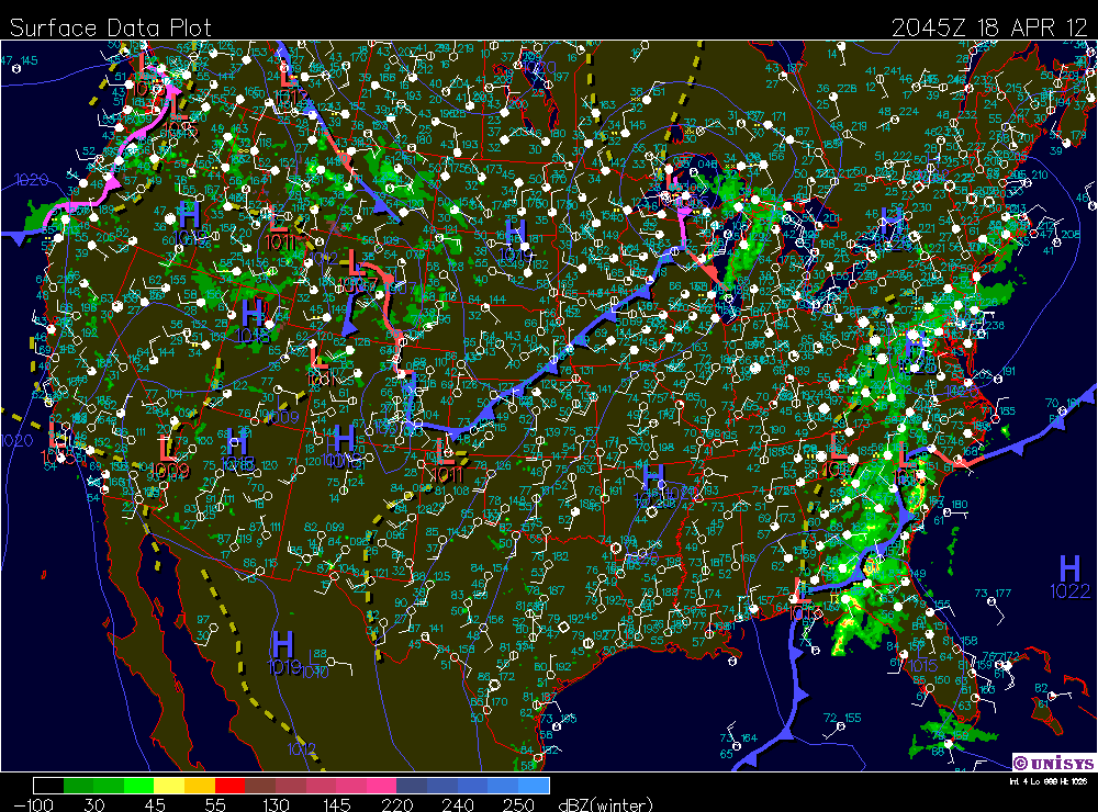
There is curerntly a low pressure crossign right over us. the wind has picked up and the clouds have increased to form a thick layer of stratus. The radar shows there is some scattered storms behind the low. There morving to the north and may or may not hit us at this point. The south wind from yester day was pretty dry and kind of killed the develpment of any storms.
Temp: 66F
Dew Point: 34F
Humidity: 30%
Wind: 8 mph S Gusts 19 mph S
Pressure: 29.88"
Today has been a picture perfect day no clouds and a high of 70, it doesn’t get much better than that. A high pressure system moved down from Canada yesterday and has been right over us all day keeping the winds calm and the skies completely clear. The high looks like it will move out tonight as a low front out of the west will take its place bringing some moist air out of the pacific. Scattered storms look like they will fallow the front. The Unisysis forecast models show possible storms in about 36 hours.
its been a while since the last post school has been completely out of hand. The weather has been really interesting lately. we've had a ton of rain and warm weather. we had a nice south wind that kept feeding mid latitude cyclones one after another for about the last week. we have finally had some good thunder storms as well. One of them this weekend was particularly nasty lightning was cracking in what sounded like the front yard for hours. Today we saw a slight change in weather pattens as a cold front moved in and created widely scattered showers instead of the intense thunderstorms.
Last night a strong line of thunder storms came through the cities, but moved north and skirted us for the most part. We did get quite a bit of rain, but the thunder and hail went around us. There was also a pocket of dry air in font of the storm and caused it to weaken as it moved over us. Right now all that water vapor is being sucked up and is being used to generate another storm. a beautiful mid latitude cyclone is over us right now. the warm south wind will bring nice temps today but also provide some serious fuel to the cyclone. We should see another potentially more powerful storm come through tonight.
Temp: 52F
Wind: 14 mph S gusts S 14 mph
Dew Point: 48F
Humidity: 58%
Pressure: 29.82"
the strong south wind has brought us pleasant temperatures today and clear skies this morning but that warm moist air is producing clouds and conditions conducive to thunderstorms are building. The clouds will build into the afternoon as the warm front to our west and the more stationary front to the south start to mix. The high pressure coming out of the rookies right now combined with the low over the mid-west will likely break apart and create a mid-latitude cyclone latter today and into tomorrow driven by the warm wet south wind I would expect thunder storms into the next 12-24 hours. The water vapor map shows high concentrations to our south as well as behind the rookie mountain high. The forecast models show in 24 hours that low pressure will be on top of us and produce precipitation. As it passes through and combines with the wet air to our south in 36 hours it will regain strength and really develop into a potentially strong mid latitude cyclone in 48 hours.
Today was a bit warmer than yester day a high pressure is just sitting over us right now. However warm weather is in the forcast this week as well as thunderstorms.
The skies have cleared as the high pressure has settled in. We have a steady north wind coming down out of Canada bringing slightly cooler air. We are under a freeze warning for tonight due to the clear skies and north wind. This system will probably stick around for a few days a bring us average temps and clear skies for the weekend.
Today is the nicest day we've had in a while thanks to the south west wind that’s bringing warm dry air our way. The skies are clear again today and should say that way until latter tonight when we might see increasing cloud cover. The forecast calls for a good chance of rain tonight as that stationary front moves our way slowly mixing with the cold front to our north.
Today has turned into a beautiful spring day, this morning was cold, but the sun quickly warmed things up. there are a few cumulous clouds floating around, coming out of the North West indicating there is nice weather on the way. A stationary front has developed on the front range of the rookies resulting in a south wind over the Midwest, A high pressure in Canada is causing the NW winds were experiencing, but there is mixing of the warmer southern air and the Canadian high over Minnesota right now. The radar is showing some scattered precipitation and cloud development as a result. The rain and clouds are moving south east towards us. We’ll probably see some clouds start to move in by latter afternoon, but this will probably dissipate and the high pressure in Canada should dominate. However once that stationary front breaks loose we could have the right conditions to produce thunderstorms. This should be watched closely over the next day or two to see what happens.
Temp: 63F
Wind: W 12 mph gusts W 36 mph
Dew Point: 44F
Humidity: 50%
Pressure: 29.86"
Last night we saw the development of a mid lattitude cyclone just to the west of us. It wasent very intense, and was probably more of an an alberta clipper. The clouds statrted to break up a few hours ago and now we have cumulous clous coming out of the west. The warm air from the south that was blowing in this morning brought some nicer weather. Things are starting to clear up and the low pressure in moving out making way for slightly cooler western air.
its 10pm and the rain still hasn't started, it looks like the line of sever weather is weakening, due to the drier air that came through earlier and cleared the skies. the dry air makes it harder to sever weather to be produced and should diminish the risk for really sever weather, however it looks like we'll still see some good thunderstorms and smaller hail. Just not the 2.5in diameter stuff they were calling for earlier. there shouldn't be to much of a risk for tornadoes either. without the moist air to fuel the storm not much will happen.
Temp: 72°F
Wind: S 23 mph gusts S 34 mph
Dew Point: 54°F
Humidity: 55%
Pressure: 29.28
well the weather is pretty crazy right now and throughout this weekend. Yesterday was beautiful a strong south wind brought nice warm air up with it, which is currently fueling the current storm system. it look like were going to get hit with by a strong well developed thunder cell last night, but it shifted just to the south of us at the last second and we only got a small amount of rain. This morning was warm and muggy, but the humidity burned off by 2, however the sky still looked threatening all afternoon. Then oddly the sky cleared completely, the sun went down over a clear blue sky in every direction. it's rare to see blue bird skies while under a tornado watch thats for sure. Right now the clouds look to be moving in but its hard to tell since its dark, but the wind is picking up and i think the temp is starting to drop, all indications of an approaching storm. the radar is showing a very strong line of storms passing through the cities right now. However the south wind is slowing the movement of the storm system. Were seeing storms right on the convergence of a low font where all the warm air is moving over the top of the cold arctic air and creating sever storms, not just here but all across the midwest. Last night 5 people were killed by a tornado in oklahoma and there looks to be equally powerful storms across the country right now.
A strong south wind has signaled a large pressure change, that began yesterday afternoon. Clouds have moved in with the low-pressure system that came out from the rookies and certainly poised to bring precipitation tonight and tomorrow. we got light rain earlier today as the leading edge of they system arrived, but this low pressure is full of moisture and could produce some thunder storms. right now the south wind is bringing warm moist air up from the gulf along the low front. it looks like there is a mid-lattitiurde cyclone enveloping in north west minnesota as the air masses start mixing. it should be interesting to see how that developed over night and into tomorrow. we might see some nice spring thunderstorms this weekend.
It's extremely calm and clear right now as we are near the center of the massive high pressure system thats occupying the central part of the country. The continental polar high brought about freezing temps last night and expected to do so agin. another freeze warning has been issued and temps could hit 24° tonight once agin putting plans in danger. this High pressure system thats broth all this sun and cold nights has really taken hold a stationary front on the edge of the rockies is gaming up a lot of moisture out west. temperatures are also much more moderate out there as well. there s also a low pressure system over the east coast right now causing some rain. This huh pressure system isn't moving very fast and will hold out again tomorrow, but the forecast is calling for clouds and rain this weekend as well as some slightly warmer temperatures.
Temp: 32°F
Wind: 4 mph NNE gusts 27mph NNE
Dew Point: 19°F
Humidity 59%
Pressure 30.21"
temperatures have already reached freezing and its only 10:43pm, it looks like the plants have a long cold night a head of them. The calm winds and the higher humidity are not helping the cause, the cold air will sink tonight and the moisture might produce some frost. The dew point is low and this air mass is very dry, but the plants are still venerable to this type of cold. Skies are till clear adding the cold conditions, the continental polar air mass has brought our temperatures down and the jet stream patterns are looking like they will hold for a few more days of clear cooler weather.
Its currently cool windy and sunny out, I think there were a few cirrus clouds overhead the last time i checked, but the satellite map shows there is clouds just to our north east. Its hard to tell weather they will hit us or not. that cloud system is a cold air mass that is producing some swirling winds and some light scattered snow in northern minnesota. The Pressure should rise thought the day as that high pressure system still hasn't quite reached us yet, so we probably won't see much for clouds.
Temperature: 59°F
Wind : 23 mph W Gusts 33 mph W
Dew Point: 20°F
Humidity: 20%
Pressure: 30.04
Currently in Janesville were experiencing some scattered showers and have stratus clouds overhead. The Radar says its not raining in Eau Claire and the clouds might be starting to break. The rain is being produced by the tail end of a warmer low pressure system as a really dry high pressure from the south west is moving our way. By tomorrow morning the weather will stabilize again and well return to dry and sunny conditions for quite some time. wind direction should switch shortly and start coming out of the south west as the front moves in. this dry continental air mass thats coming through is also bringing a fire weather warning for Wisconsin. Since the air is so dry and the wind is so high were have good conditions for fire. That's a warning you don't see very often around here, however temps are below the critical burn point so we should be alright.
temperature: 61°F
Wind: NE 12 mph gusts NE 19 mph
Dew Point: 25°F
Humidity: 25%
Pressure: 30.00"
Today is a beautiful spring day the skies are completely clear and the temperature is pleasant. The High pressure system that moved in last night has really stabilized the weather and not much is going on in Eau Claire today.
The violent tornados that ripped through dallas yesterday didn't claim any lived, but it looks like it did some significant damage. Hundreds of homes and business were destroyed or damaged, there some nasty pictures of semi trailers that were picked up and thrown.
Temp: 60°F
Wind: 6 mph NE Gust NE 24 mph
Dew Point: 24°F
Humidity: 25%
Pressure: 30.00"
Last night a rather powerful yet small thunderstorm rolled throughout Eau Claire at about 2 am. It left .22 in of rain as well as some hail that probably woke just about everyone up. Thunder and lightning was also prevalent while the storm lasted, however it moved through pretty quickly. This morning was cool and damp humidity was around 80% at 8am due to the cold air and the high amount of water vapor contained in the front. Stratus clouds covered the sky till about 2 or 3 this after noon. Then the sun began to shine as higher pressure moved in from the west, and pushed out the storm system. Clear skies and mild temperatures looks like they will stick around for a while.
As we were drying up from last night's rain a texas size storm swept through the dallas area. At least 3 tornados have been reported in the Dallas - Ft. Worth area. A tornado emergency has been called for in dallas, two large paths of destruction have been reported. semis were picked up and thrown, roofs were ripped off houses, and gold ball size hail as well and intense lightning was reported. However one of the most interesting things about this storm is that is was live blogged. I was able to read up to the minute tweets of the events, and see pictures and videos of tornados as they were happening. Apparently thats will happen when such a large storm hits such a populated area.