Current Conditions: 4:00 PM
Temp: 52F
Wind: N 6 mph Gusts N25 mph
Dew Point: 24F
Humidity 34%
Pressure: 30.12"
The skies have cleared as the high pressure has settled in. We have a steady north wind coming down out of Canada bringing slightly cooler air. We are under a freeze warning for tonight due to the clear skies and north wind. This system will probably stick around for a few days a bring us average temps and clear skies for the weekend.
Thursday, April 26, 2012

Tuesday, April 24, 2012
Tuseday's Weather
Current Conditions: 10:35 am
Temp: 56F
Wind: SSW 7mph Gusts SSW 6 mph
Dew Point: 28F
Humidity: 34%
Pressure: 29.75"
Today is the nicest day we've had in a while thanks to the south west wind that’s bringing warm dry air our way. The skies are clear again today and should say that way until latter tonight when we might see increasing cloud cover. The forecast calls for a good chance of rain tonight as that stationary front moves our way slowly mixing with the cold front to our north.

Temp: 56F
Wind: SSW 7mph Gusts SSW 6 mph
Dew Point: 28F
Humidity: 34%
Pressure: 29.75"
Today is the nicest day we've had in a while thanks to the south west wind that’s bringing warm dry air our way. The skies are clear again today and should say that way until latter tonight when we might see increasing cloud cover. The forecast calls for a good chance of rain tonight as that stationary front moves our way slowly mixing with the cold front to our north.
Monday, April 23, 2012
Monday's Weather
Current Conditions: 2:37 pm
Temp: 6oF
Wind: NW 12 mph Gusts NW 19 mph
Dew Point: 34F
Humidity: 38%
Pressure: 30.02"
Today has turned into a beautiful spring day, this morning was cold, but the sun quickly warmed things up. there are a few cumulous clouds floating around, coming out of the North West indicating there is nice weather on the way. A stationary front has developed on the front range of the rookies resulting in a south wind over the Midwest, A high pressure in Canada is causing the NW winds were experiencing, but there is mixing of the warmer southern air and the Canadian high over Minnesota right now. The radar is showing some scattered precipitation and cloud development as a result. The rain and clouds are moving south east towards us. We’ll probably see some clouds start to move in by latter afternoon, but this will probably dissipate and the high pressure in Canada should dominate. However once that stationary front breaks loose we could have the right conditions to produce thunderstorms. This should be watched closely over the next day or two to see what happens.

Temp: 6oF
Wind: NW 12 mph Gusts NW 19 mph
Dew Point: 34F
Humidity: 38%
Pressure: 30.02"
Today has turned into a beautiful spring day, this morning was cold, but the sun quickly warmed things up. there are a few cumulous clouds floating around, coming out of the North West indicating there is nice weather on the way. A stationary front has developed on the front range of the rookies resulting in a south wind over the Midwest, A high pressure in Canada is causing the NW winds were experiencing, but there is mixing of the warmer southern air and the Canadian high over Minnesota right now. The radar is showing some scattered precipitation and cloud development as a result. The rain and clouds are moving south east towards us. We’ll probably see some clouds start to move in by latter afternoon, but this will probably dissipate and the high pressure in Canada should dominate. However once that stationary front breaks loose we could have the right conditions to produce thunderstorms. This should be watched closely over the next day or two to see what happens.
Wednesday, April 18, 2012
Wednesday Weather
Current Conditions: 4:30 pm
Temp: 63F
Wind: W 12 mph gusts W 36 mph
Dew Point: 44F
Humidity: 50%
Pressure: 29.86"
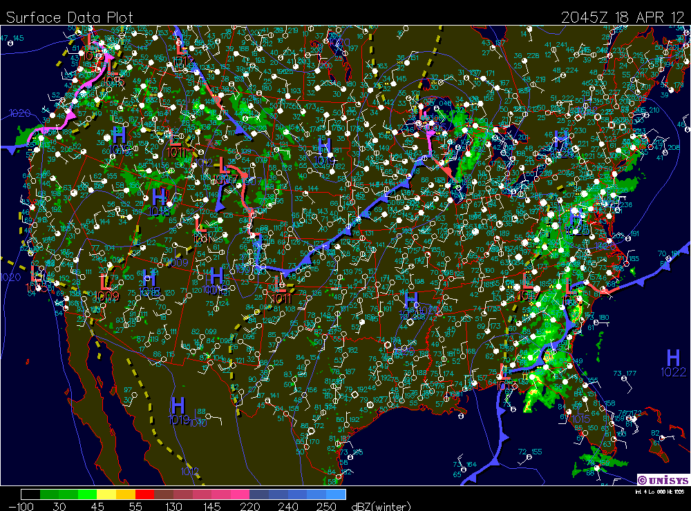
Last night we saw the development of a mid lattitude cyclone just to the west of us. It wasent very intense, and was probably more of an an alberta clipper. The clouds statrted to break up a few hours ago and now we have cumulous clous coming out of the west. The warm air from the south that was blowing in this morning brought some nicer weather. Things are starting to clear up and the low pressure in moving out making way for slightly cooler western air.
Temp: 63F
Wind: W 12 mph gusts W 36 mph
Dew Point: 44F
Humidity: 50%
Pressure: 29.86"
Last night we saw the development of a mid lattitude cyclone just to the west of us. It wasent very intense, and was probably more of an an alberta clipper. The clouds statrted to break up a few hours ago and now we have cumulous clous coming out of the west. The warm air from the south that was blowing in this morning brought some nicer weather. Things are starting to clear up and the low pressure in moving out making way for slightly cooler western air.
Sunday, April 15, 2012
storm update
its 10pm and the rain still hasn't started, it looks like the line of sever weather is weakening, due to the drier air that came through earlier and cleared the skies. the dry air makes it harder to sever weather to be produced and should diminish the risk for really sever weather, however it looks like we'll still see some good thunderstorms and smaller hail. Just not the 2.5in diameter stuff they were calling for earlier. there shouldn't be to much of a risk for tornadoes either. without the moist air to fuel the storm not much will happen.


saturday/sunday weather
Current Conditions
Temp: 72°F
Wind: S 23 mph gusts S 34 mph
Dew Point: 54°F
Humidity: 55%
Pressure: 29.28
well the weather is pretty crazy right now and throughout this weekend. Yesterday was beautiful a strong south wind brought nice warm air up with it, which is currently fueling the current storm system. it look like were going to get hit with by a strong well developed thunder cell last night, but it shifted just to the south of us at the last second and we only got a small amount of rain. This morning was warm and muggy, but the humidity burned off by 2, however the sky still looked threatening all afternoon. Then oddly the sky cleared completely, the sun went down over a clear blue sky in every direction. it's rare to see blue bird skies while under a tornado watch thats for sure. Right now the clouds look to be moving in but its hard to tell since its dark, but the wind is picking up and i think the temp is starting to drop, all indications of an approaching storm. the radar is showing a very strong line of storms passing through the cities right now. However the south wind is slowing the movement of the storm system. Were seeing storms right on the convergence of a low font where all the warm air is moving over the top of the cold arctic air and creating sever storms, not just here but all across the midwest. Last night 5 people were killed by a tornado in oklahoma and there looks to be equally powerful storms across the country right now.
 Clear skies from earlier today...Weird


Temp: 72°F
Wind: S 23 mph gusts S 34 mph
Dew Point: 54°F
Humidity: 55%
Pressure: 29.28
well the weather is pretty crazy right now and throughout this weekend. Yesterday was beautiful a strong south wind brought nice warm air up with it, which is currently fueling the current storm system. it look like were going to get hit with by a strong well developed thunder cell last night, but it shifted just to the south of us at the last second and we only got a small amount of rain. This morning was warm and muggy, but the humidity burned off by 2, however the sky still looked threatening all afternoon. Then oddly the sky cleared completely, the sun went down over a clear blue sky in every direction. it's rare to see blue bird skies while under a tornado watch thats for sure. Right now the clouds look to be moving in but its hard to tell since its dark, but the wind is picking up and i think the temp is starting to drop, all indications of an approaching storm. the radar is showing a very strong line of storms passing through the cities right now. However the south wind is slowing the movement of the storm system. Were seeing storms right on the convergence of a low font where all the warm air is moving over the top of the cold arctic air and creating sever storms, not just here but all across the midwest. Last night 5 people were killed by a tornado in oklahoma and there looks to be equally powerful storms across the country right now.


Friday, April 13, 2012
Fridays Weather
Current Conditions
Temp: 54°F
Wind: SSE 17 mph gusts SSE 27 mph
Dew Point: 36°F
Humidity: 51%
Pressure: 29.90"
A strong south wind has signaled a large pressure change, that began yesterday afternoon. Clouds have moved in with the low-pressure system that came out from the rookies and certainly poised to bring precipitation tonight and tomorrow. we got light rain earlier today as the leading edge of they system arrived, but this low pressure is full of moisture and could produce some thunder storms. right now the south wind is bringing warm moist air up from the gulf along the low front. it looks like there is a mid-lattitiurde cyclone enveloping in north west minnesota as the air masses start mixing. it should be interesting to see how that developed over night and into tomorrow. we might see some nice spring thunderstorms this weekend.

Temp: 54°F
Wind: SSE 17 mph gusts SSE 27 mph
Dew Point: 36°F
Humidity: 51%
Pressure: 29.90"
A strong south wind has signaled a large pressure change, that began yesterday afternoon. Clouds have moved in with the low-pressure system that came out from the rookies and certainly poised to bring precipitation tonight and tomorrow. we got light rain earlier today as the leading edge of they system arrived, but this low pressure is full of moisture and could produce some thunder storms. right now the south wind is bringing warm moist air up from the gulf along the low front. it looks like there is a mid-lattitiurde cyclone enveloping in north west minnesota as the air masses start mixing. it should be interesting to see how that developed over night and into tomorrow. we might see some nice spring thunderstorms this weekend.

Subscribe to:
Posts (Atom)